Selwood forest was owned by the King who leased it to a bailiff/forester, who charged tolls for travel through parts of it and for feeding animals on the land. It was not just woodland but included open heathland and small communities. It would appear from Canon Jackson’s article below that Langham and the Wiltshire part of Rode Commom (if not all of it) was once part of this huge forest. The forest was subject to strict hunting laws and Batten Pooll in his “A West Country Potpourri” tells of an infringement in 1286: “when Reginald Kingston, custos of Selwood forest, complained that in Easter week Nicholas de Montford of Tellesford, and Richard le Vag, both outlaws, entered the forest at La Frith near Tellesford, and took with nets a stag in the water at Tellesford – the forest here was part of the Royal forest of Selwood.”
Extracts from an Article in the Wiltshire archaeological and natural history magazine vol.23 no.67-69 (1886-1887)
Article Title: Selwood Forest. Author: Canon J. E. Jackson (nb: see images of the magazine article below).
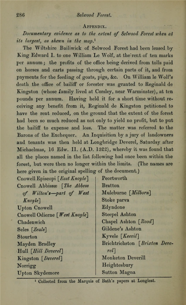
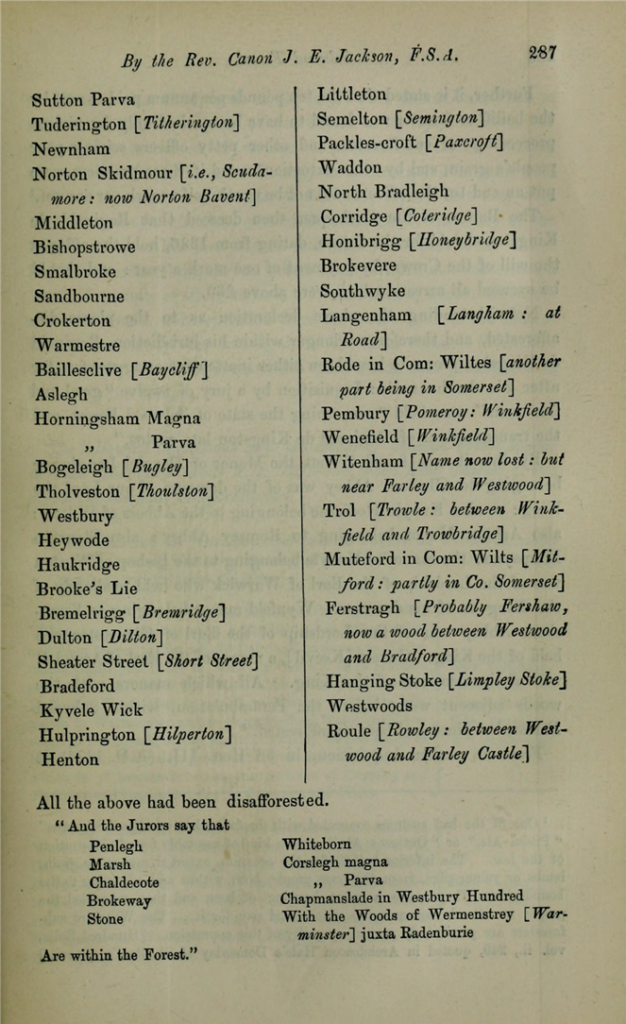
pp286/287: An Inquisition by a jury of landowners and tenants was then held at Longbridge Deverel, Saturday after Michaelmas, 16 Edw.II (AD 1322), whereby it was found that all the place names in the list following had once been within the forest, but were then no longer within the limits. (The names are here given in the original spelling of the document.) Langenham [Langham: at Road] Rode in Com: Wiltes [another part being in Somerset]. All the above had been disafforested
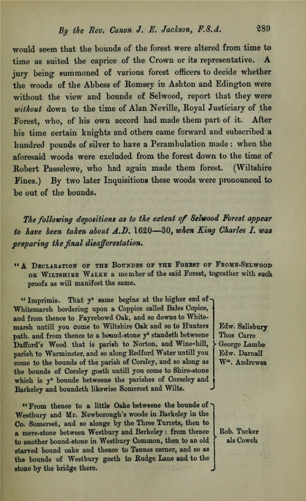
p289/290: The following depositions as to the extent of Selwood Forest appear to have been taken about A. D. 1620-30, when King Charles I was preparing the final disafforestation.
- Imprimis. That ye begins at the higher end of Whitemarsh ………
- From thence to a little Oake …. and so as the bounds of Westbury goeth to Rudge Lane and to the stone by the bridge there.
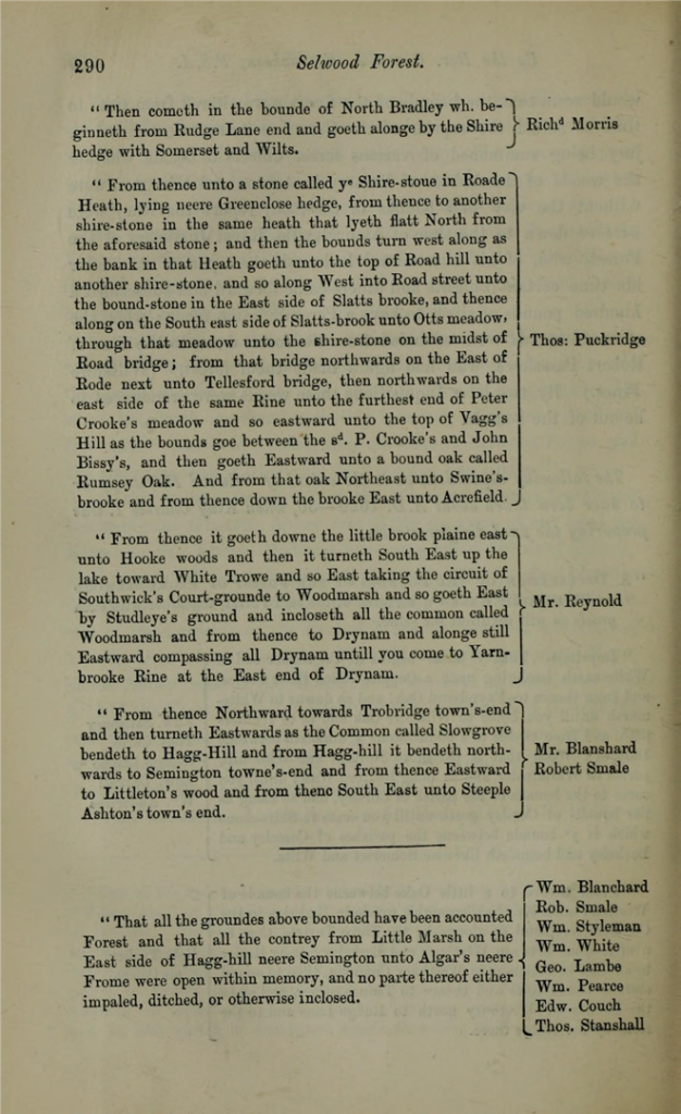
- Then cometh in the bounde of North Bradley wh. beginneth from Rudge Lane end and goeth alonge by the Shire hedge Somerset and Wilts.
From thence unto a stone called ye Shire-stoue (stone) in Roade Heath, lying neere Greenclose (nos.481/2/3 on Rode tithe map) hedge, from thence to another shire-stone in the same heath that lyeth flatt North from the aforesaid stone; and then the bounds turn west along as the bank in that Heath goeth unto the top of Road hill unto another shire stone, and so alon West into Road street unto the bound-stone in the East side if Slatts-brook unto Otts meadow, though that meadow unto the shire-stone on the midst of Road bridge; from that bridge northwards on the East of Rode (river Frome) next unto Tellesford bridge, then northwards on the East side of the same Rine unto unto the furthest end of Peter Crooke’s meadow and so eastward unto the top of Vagg’s Hill as the bounds goe between the sd. P. Crooke’s and John Bissy’s, and then goeth Eastward unto a bound oak called Rumsey Oak. And from that oak Northeast unto Swine’s-brooke and from thencedown the broe East unto Acrefield.
The latter depositionwas given by Thomas Puckridge. (Parish registers show a Thomas Pockerige married c1600 who died in 1629 and his son Thomas baptised in 1611 who married in 1647.)