County Boundary
From: 964 see Saxon charter of Steeple Ashton; 1630 see perambulation of Selwood Forest; 1763 see Court Leet; 1773 see Andrews and Dury map; 1792 see Rode Common enclosure map; 1800 see SRO document; 1805 see 1805 draft survey map of Rode Hill; 1839/1841 see Tithe Maps; 1937 see OS maps
c964 Boundary of Steeple Ashton in the vicinity of Rode
Extract from THE SAXON LAND CHARTERS OF WILTSHIRE (page 70)
Charter recording the grant of lands including the whole of Steeple Ashton, West Ashton, North Bradley and Southwick, all about 4? miles from Bradford-on-Avon B.1127. Not in K. RD. A.D. 964. Sets forth the king’s tenure of the lands concerned. Hides ? (Numeral omitted; but, on the evidence of Domesday, probably 40).
(page 71) Name: Ashtone: Aystone. Ident. B. Steeple Ashton Wilts.
The survey is certainly not of the Saxon age; and it may be doubted whether it goes back to any original of that age. The extant copy dates from about the time of Edward I (1272-1307). This is shown by the form of the name Hulpryn mor (see 23 of the survey). The form of the name of Ashton in the body of the document points to about the same date. Survey:
1. Aerest on Semnit: “First to Semnit.”
It may be expected that this name is somewhat corrupted in the extant text. But it is at any rate possible to identify it with the brook which, starting from the NE. corner of Steeple Ashton parish, 5 fur. due N. of the church, runs past Bleet (OM1) forming the E. part of the N. by. of the parish, and part of the S. by. of Semington; …..
(page 73)
- Of, etc. on Mealm: “From the river Biss to Malm.”
Malm is a friable soil. The term is common in field names. But, though I have translated mealm in this way, I strongly suspect that its identity of form with the Saxon term is accidental, and that it is a pre-Saxon river name applying to the upper part of the Biss, that now called Biss Brook. The by. follows the Biss Brook as far as Brook House, where another stream mentioned in the next landmark of the charter enters the Biss.
- Than on Alleburne: “Then to Alder (?) Bourne.”
This is the stream which enters Biss Brook by Brook House (OM1), after forming the SE. by. of Southwick parish.
- Thanen on Fromesetinga Hagen: “Then to the Deer Fence (Game Enclosure) of the Dwellers about Frome.”
This brings the survey to the Somerset by. at the SW corner of Southwick parish, ? m. SSE of Rudge (OM1). The Haga ran evidently along by the W. by. of Southwick; but how far N. it went cannot be said, for the next landmarks of the charter are not now determinable. But probably it went all the way along the more or less straight piece of by. which ends at the road from Southwick to Road.
- Of, etc. on Wuntfeld: “From the game enclosure to the Open Country of . . .”
- And thanen on Burgredes Rode: “And then to Burgred’s Rood (Cross).”
page 74
- Of, etc. on Marcbrok: “From the Rood to Boundary Brook”
Reckoning from the landmarks which follow shows that this is the brook which forms the W. part of the N. by. of Southwick. In the Bradford charter it is called Swinbroch, “Swine Brook.”
But it is noticeable that 16 and 17 do not mention the river Frome which at present day forms the N. part of the W. by. of Southwick. It looks as if there had been some rearrangement of boundary in this part, perhaps at the time at which Road Common was enclosed. I suspect wuntfeld to be an error for Wunkfeld, and to be a medieval form of Winkfield, the neighbouring parish.
Comments by Peter Harris:
15 to 18 could be a description of the Somerset Wilts boundary from Rudge, to Rode Common, into the town of Rode, along the river Frome to Tellisford, and thence along the N. Bradley (Southwick) Wingfield boundary to Swinebrook. However, Langham was sometimes included in with the Manor of Rode so it is more likely it is a description of the old western boundary of N. Bradley parish excluding Langham, i.e.
- north along the Somerset/Wilts boundary from Rudge, to the edge of Rode Common,
- continue north along the county boundary to the centre of the common where the county boundary turned west,
- continue north along the N. Bradley/Langham boundary to the boundary of Wingfield (to a cross, either where the Rumsey Oak once stood, or perhaps at the junction of the track from Tellisf ord to Poplar Tree Lane and the track from Rode to Wingfield)
- east along the N. Bradley (Southwick) /Wingfield boundary to Swine brook.
- And thanen on Lambrok: “And then to Lamb Brook.” I suspect that the same name was AS. Lam-broc, “clay brook.” OM6 does not show whether there is any brook along the N. by. of North Bradley, though that by. has the wavy character of one following a brook. If it does, then that is Lam(b)brok of the charter. If not, then the brook is that which passes along the N. by. of Southwick N. and NE. of the village.
- And thanen on Haranmere: And then to Hare Pond
1630 – Selwood Forest and County Boundary in the vicinity of Rode
Extract from an Article in the Wiltshire archaeolical and natural history magazine vol.23 no.67-69 (1886-1887) pp289/290. Article Title: Selwood Forest. Author: Canon J. E. Jackson
The following depositions as to the extent of Selwood Forest appear to have been taken about A. D. 1620-30, when King Charles I. was preparing the final disafforestation.
- Imprimis. That ye begins at the higher end of Whitemarsh ….
- From thence to a little Oake …. and so as the bounds of Westbury goeth to Rudge Lane and to the stone by the bridge there.
- Then cometh in the bounde of North Bradley wh. beginneth from Rudge Lane end and goeth alonge by the Shire hedge Somerset and Wilts.
- From thence unto a stone called ye Shire-stoue (stone) in Roade Heath, lying neere Greenclose (nos. 481/2/3 on Rode tithe map) hedge, from thence to another shire-stone in the same heath that lyeth flatt North from the aforesaid stone; and then the bounds turn west along as the bank in that Heath goeth unto the top of Road hill unto another shire stone, and so alon West into Road street unto the bound-stone in the East side if Slatts-brook unto Otts meadow, though that meadow unto the shire-stone on the midst of Road bridge; from that bridge northwards on the East of Rode (river Frome) next unto Tellesford bridge, then northwards on the East side of the same Rine unto unto the furthest end of Peter Crooke’s meadow and so eastward unto the top of Vagg’s Hill as the bounds goe between the sd. P. Crooke’s and John Bissy’s, and then goeth Eastward unto a bound oak called Rumsey Oak. And from that oak Northeast unto Swine’s-brooke and from thencedown the broe East unto Acrefield.
The latter deposition was given by Thomas Puckridge.
Parish registers show a Thomas Pockerige married c1600 who died in 1629 and his son Thomas baptised in 1611 who married in 1647.
1763 Court Leet of Rode Manor and Hundred of Whitway
“We Present that the said Stone called the White Stone Doth part the Counties of Somerset and Wilts, and the said Flint set in the Slabb doth part the Lordships of Road and Langham and Southwick.”
(We Present the Bounds of the Common of Road and Langham to be from the Flint Stone at William Dowling’s Green Close Gate to a Flint Stone near White Stone lying in a Slabb and from thence to a Stone called the Grey Stone and from thence to a Stone where Meer Oak stood and from thence to Rumsey Oak now standing near Bissey’s Bushes and from thence round Vagg’s Hill to the Lane that Leads from Tellisford Bridge to Vagg’s Hill and from thence Down the other side of Vagg’s Hill and from thence to a House called Dixes and from thence up to Road Hill and from thence down to the River runing under Road Mill Bridge which said Lane is within the Manor of Road and Langham aforesaid.)
1800 – D/P/rode 20/1/4
This records an award respecting the boundary between the Parishes of Road (in Somerset) and North Bradley (in Wiltshire) dated 4th, January 1800:
“begins at Manor Pound of Road and Langham and runs in a north eastward direction to an ancient boundary stone in an allotment of land on the said Common and sold by the Commissioners of the said Inclosure to Mary Ponting and from there across the highway to the southwest corner of an allotment made to Joseph Houlton near a place called Birchin Leaze corner and from there eastwards by the boundary fence of the said allotment to the south east corner of the said allotment at a place called Road Hill Crossways and from there in a northeastward direction by the boundary fence of the said allotment to the public road leading from Road to Bradford and by the boundary fences of allotments made respectively to Daniel Clutterbuck, Esq., the Churchwardens of Road, John Mortimer, William Collier, William Stevens, William Dyer, Edward Tovey and Henry Tovey, Joseph Greenhill and Stephen Hillman abutting on the said public road and from there in the same direction by the boundary fence of an allotment made to Daniel Clutterbuck by the length of about 12 poles and from thence in a south easterly direction across the said public road to the end of the NE boundary of an allotment made to Robert Hayward and thence in the same direction by the said boundary fence and by the northeast boundary fence of an allotment made to John Edwards to the end of the said boundary fence adjoining the NW fence of an allotment sold by the Commissioners of the said Inclosure to John Thomas and from there in an eastwards direction by the said NW boundary fence of the last mentioned allotment to an ancient boundary stone called the Ezey Mere Stone on the edge of the said boundary fence and from there by the same boundary fence to the end of the said fence on the edge of Southwick Common in the Parish of North Bradley.”
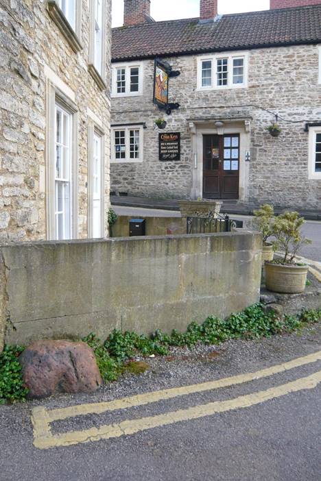
Above: County boundary stone at junction of High Street and Lower Street (referred to in the 1630 article “and so alon West into Road street unto the bound-stone in the East side if Slatts-brook unto Otts meadow”. The brook now runs underground from behind 8 High Street, along the back of 19 High Street and down Lower Street, emerging in the field behind Mogg Hill cottages.
A similar stone in the front garden of what is now 4 Hughes Court was removed when the building was renovated in the 1980s
Rode Parish Boundary
Rode cum Woolverton
Extract from A History of the Established Church in Rode, by B Foyston 2007: The once separate parishes of Road and Woolverton, though manorially linked since the Norman Conquest, had been united as Road cum Woolverton since 1738, with what is now the Woolverton House Hotel replacing the previous parsonage house in the 1870s, a move which was not universally welcomed:
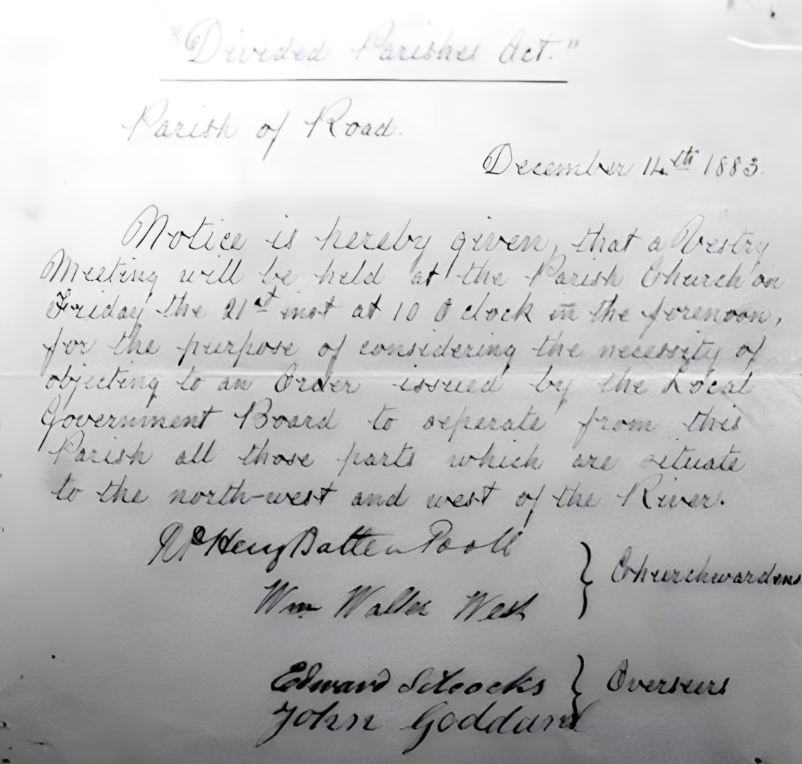
A NOTICE OF A ROAD VESTRY MEETING IN 1883 REGARDING THE ‘DIVIDED PARISHES ACT’
During the last half of the nineteenth century the loss of parish autonomy accelerated and little remained other than the rating system and church organisation. There was a growing move to establish civil parishes by separating the lay and ecclesiastical features of local administration and this came about in 1894. Also during this time efforts were made to remove the anomalies of divided parishes and in 1883 Road received an Order from the Local Government Board concerning this matter. Below is a copy of a Notice (dated 14th December 1883) about a meeting to be called to discuss the Board’s proposals. The parish boundary today tells the outcome.
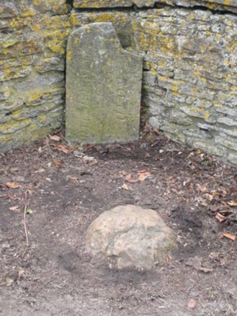
County and parish boundary stones in the refuge on Rode Bridge (see image below): The parish boundary stone (the grey upright slab) has a vertical line down its face and on the left (east) is inscribed NORTH BRADLEY and on the right (west) ROAD. This would indicate that it dates from the period 1783 to 1883 when Rode and Woolverton were administered as the combined parish of Road cum Woolverton.
Rode Common Boundary
(From: 964 see Saxon charter of Steeple Ashton; 1630 see perambulation of Selwood Forest; 1763 see Court Leet; 1773 see Andrews and Dury map; 1792 see Rode Common enclosure map)
1630 – Selwood Forest and County Boundary in the vicinity of Rode
Extract from: an Article in the Wiltshire archaeological and natural history magazine vol.23 no.67-69 (1886-1887) pp289/290. Article Title: Selwood Forest. Author: Canon J. E. Jackson
The following depositions as to the extent of Selwood Forest appear to have been taken about A. D. 1620-30, when King Charles I. was preparing the final disafforestation.
- Imprimis. That ye begins at the higher end of Whitemarsh ….
- From thence to a little Oake …. and so as the bounds of Westbury goeth to Rudge Lane and to the stone by the bridge there.
- Then cometh in the bounde of North Bradley wh. beginneth from Rudge Lane end and goeth alonge by the Shire hedge Somerset and Wilts.
- From thence unto a stone called ye Shire-stoue (stone) in Roade Heath, lying neere Greenclose (nos. 481/2/3 on Rode tithe map) hedge, from thence to another shire-stone in the same heath that lyeth flatt North from the aforesaid stone; and then the bounds turn west along as the bank in that Heath goeth unto the top of Road hill unto another shire stone, and so alon West into Road street unto the bound-stone in the East side if Slatts-brook unto Otts meadow, though that meadow unto the shire-stone on the midst of Road bridge; from that bridge northwards on the East of Rode (river Frome) next unto Tellesford bridge, then northwards on the East side of the same Rine unto unto the furthest end of Peter Crooke’s meadow and so eastward unto the top of Vagg’s Hill as the bounds goe between the sd. P. Crooke’s and John Bissy’s, and then goeth Eastward unto a bound oak called Rumsey Oak. And from that oak Northeast unto Swine’s-brooke and from thencedown the broe East unto Acrefield.
The latter deposition was given by Thomas Puckridge.
Parish registers show a Thomas Pockerige married c1600 who died in 1629 and his son Thomas baptised in 1611 who married in 1647.
1763 Court Leet
A presentment made at the Court Leet held in and for the Manor aforesaid on Thursday the 28th day of April 1763 and in the Third Year of the Reign of George the Third King of Great Brittain etc. and the Court of Edward Andrews Esqr. Lord of the said Manor there held before William Corp Gent. Steward:
“We Present the Bounds of the Common of Road and Langham to be from the Flint Stone at William Dowling’s Green Close Gate to a Flint Stone near White Stone lying in a Slabb and from thence to a Stone called the Grey Stone and from thence to a Stone where Meer Oak stood and from thence to Rumsey Oak now standing near Bissey’s Bushes and from thence round Vagg’s Hill to the Lane that Leads from Tellisford Bridge to Vagg’s Hill and from thence Down the other side of Vagg’s Hill and from thence to a House called Dixes and from thence up to Road Hill and from thence down to the River runing under Road Mill Bridge which said Lane is within the Manor of Road and Langham aforesaid.”